Map:
Terrain/Rating:
Day 1 Flat beach walk / Easy , Day 2 Hilly (600m) / MediumStart Time:
11am
Start / Finish Location:
Freycinet Peninsular Carpark
Trip Detail Summary:
Start at Freycinet Carpark, walking along Hazards Beach to camp at Cooks Hut campsite overnight, heading back to the carpark via Mt Graham the next day.
Trip Details:
For this trip we arrived in Launceston Friday evening and stayed at the nearby Treasure Island Caravan Park in Glen Dhu, which is suburb about a 5 minute drive away from the airport heading towards Launceston.
 |
| Treasure Island Caravan Park |
The drive from Launceston to the Freycinet Peninsular should take no more than 2 hours.
Coles Bay is the closest town (15 mins) to the Peninsular and is a pretty location for a coffee and has a general store to pickup any late minute items.
From Coles Bay you can view the Freycinet Peninsular across the bay.
We could see inclement weather was in store for us on this hike.
 |
| Coles Bay |
You can buy a Parks Pass either at the carpark or from the Park Information Centre.
The Park Information Centre is on the main road from Coles Bay to the Peninsular carpark.
There are toilets here as well as at the carpark.There are no showers at the Park Center unfortunately.
We arrived at the carpark at 10:45am and were immediately greeted by a pair of pandamelons with joeys, which seem to have made the carpark their home and feeding ground.
Our hike began at 11am.
There is an intentions book at the shelter should be signed if you are doing any overnight camping.
 |
| Track Start |
For our trip we bypass the lookout,.
After heading a few 100m along the main track we turn right and head off down the track towards Hazards Beach.
The wide track narrows quickly to a path which works its way around the bay.
Some nice granite boulders inland and views of the water can be seen along this section of the track.
After 30 mins or so the track heads downwards through some densely forested areas for a few hundred meters.
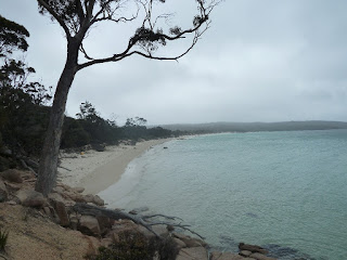
About an hour into the walk we arrive at the sandy shores of Hazards Beach.
 |
| Start of Hazards Beach. |
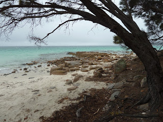
A pleasant day for walking but the lack of sun prevented the colours coming out from the water and the famous orange granite.
After walking along Hazards Beach for 30 minutes it was decided to take a lunch break on the beach while the weather was reasonable, as the weather looked more threatening further on.
 |
| Hazards Beach. |
Another 30 minutes along the sandy shores we end at the Hazards Beach campsite (which has pit toilets)
We continue on as the track works its way back into forest area but keeps close to the shoreline.
We follow Peninsula track through the forest for about 30 minutes before arriving at the shores of Cooks Beach. There is a track junction here where the Peninsula track heads inland, over the mountains and back to Wineglass Bay. This is the return track we take tomorrow morning.
 |
| View arriving at Cooks Beach. |
 |
| Start of Cooks Beach. |
For our destination today, we head along the beach for a short 15 minute walk to the Cooks Beach Campsite.
 |
| Cooks Beach Campsite. |
Arriving at the Cooks Beach campsite you have a few camping options.
You can camp near the beach or up to 100m inland near Cooks Hut. The campsite is well treed and pretty sheltered from the beach especially closer to the hut.
At the time of our trip Cooks Hut was boarded up. I have no idea whether it will be re-opened.
There are 3 water tanks that get fed off its roof with only one being available whilst we were there. There seemed to be plenty of water in the tank but we were there at the end of the winter period. so in summer best to carry in your own water.
 |
| Cooks Hut. |
The campsite has a pretty beach to relax at.
 |
| Cooks Hut campsite beach. |
The next morning we head back down the beach the way we came back to the Peninsula track junction to head inland. This is a longer walk than yesterdays so a earlier start was planned at 9am.
 |
| Peninsula track over Freycinet Saddle. |
The weather was windy, cool and wet which we thought might make the track tricky as we had read that it could be slippery on the rocks along the way. I can only recall 2 spots along the track that I would say you had to pay attention to when walking but no real scary or dangerously slippery areas.
 |
| Peninsula track over Freycinet Saddle. |
The walk through this area took 1-2 hours before you reach the Southern rend of the Wineglass Bay beach.
There is a Camping area and pit toilet here, very basic.
For our 2 day hike, we continue on along the beach.
The walk along the beach is a little over 1km.
We reached the other end of the bay /Wineglass Bay track within 20 mins.
It takes another 30min to walk up the hill to the intersection with the Wineglass Bay Lookout track.
This side track only takes 2 minutes to get to the lookout, worthwhile sidetrip on a clear day.
From the lookout intersection its 40 min mainly downhill walk back to the carpark.
If doing this hike remember to sign out of the intentions book.
Allow 2 hours to get back to the Launceston Airport.


