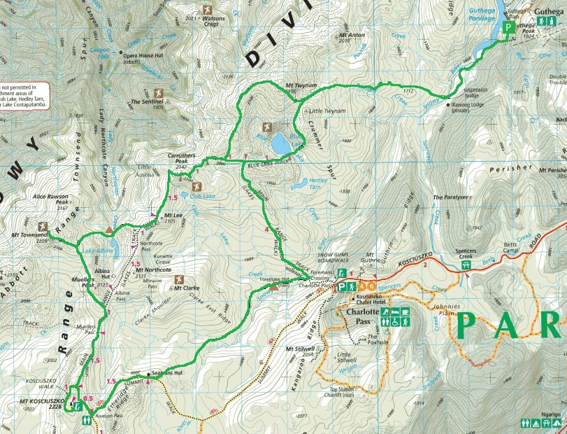
Walk: Main Ridge / Mt. Kosciuszko / Mt Townsend Circuit from Guthega
Distance/Rated Duration/Type: Hike 45km / 3 Days / Figure 8 Loop
Detailed information: Wild Walks - Main Ridge circuit
Map:
Terrain/Rating: Mountainous terrain in varying conditions / Hard
Start / Finish Time:
Day 1: 9:00AM / 5:30PM
Day 2 9:00AM / 3:00PM
Day 3 9:00AM / 3:00PM
Start / Finish Location:
Start / Finish Location:
Guthega / Guthega
Trip Summary:
One of my favourite walks in Australia.
Trip Summary:
One of my favourite walks in Australia.
Combining on & off track hiking this walk transverses the pristine and iconic Snowy River near its headwaters.
You will walk by snow scattered mountains, have great high views above the aqua coloured Blue Lake, climb the two highest mountain peaks in Australia, with spectacular alpine views each day.
With the weather capable of changing within minutes, this hike has it all.
From Guthega Alpine Inn head along the Snowy River before crossing over and walking offtrack up into the mountains.
Walk down into the valley near Blue Lake before working your way up to Main Ridge crossing over Twynam track, then camp down near Albina Lake.
Head up to the 2nd highest mountain in Australia (Townsend) then work along track to Mt Kosciuszko. From there head past Seamans Hut, offtrack into the valley to camp near Foremans Hut ruins next to the Snowy River.
The next day cross over creek, then up Main Ridge track across Blue Lake track up to Mt. Twynam. From Mt Twynam head off track thru woods past Blue Lake down to Snowy River again before making it back to Guthega.
Detailed Topo Maps, Compass/GPS and PLB are essential.
Details on the Wild Walks website which recommends a 4 day hike. We did this hike in 3 days with a very long first day.
How to get there:
From Jindabyne take the Kosciuszko Road north. Turn right into Guthega Road and drive to the end.
Park near the Guthega Alpine Inn / Guthega Pondage.
Accomodation:
For a good base camp 20 minutes from the start, stay at Island Bend campground along Guthega Road. It is free and has a pit toilet.
 |
| Island Bend campground |
If you want a hot shower & toilet then the closest campgrounds are at Lake Jindabyne.
Trip Detail:
Head down the concrete road from the main Guthega Road.
Head down the concrete road from the main Guthega Road.
 |
| Guthega start of trek |
Continue onto the dirt track (with small boulders at entrance).
Head along the track and down the valley, with Snowy River on your right until you reach Blue Cow Creek.
 |
| Heading down to Blue Cow creek |
Either walk across the rocks on the creek or use the Flying Fox if the water level is high.
 |
| Blue Cow creek |
Continue walking along the bush track parallel to the Snowy River.
After about 50 mins you will arrive at Illawong Lodge, which is an emergency shelter.
 |
| Arriving at Illawong Lodge |
Head down to the suspension bridge and cross the Snowy River.
 |
| View from other side of Snowy River |
From here the track becomes faint and you will need to rely on Topo Maps and Compass/GPS.
 |
| Heading up to Pounds Creek Flats |
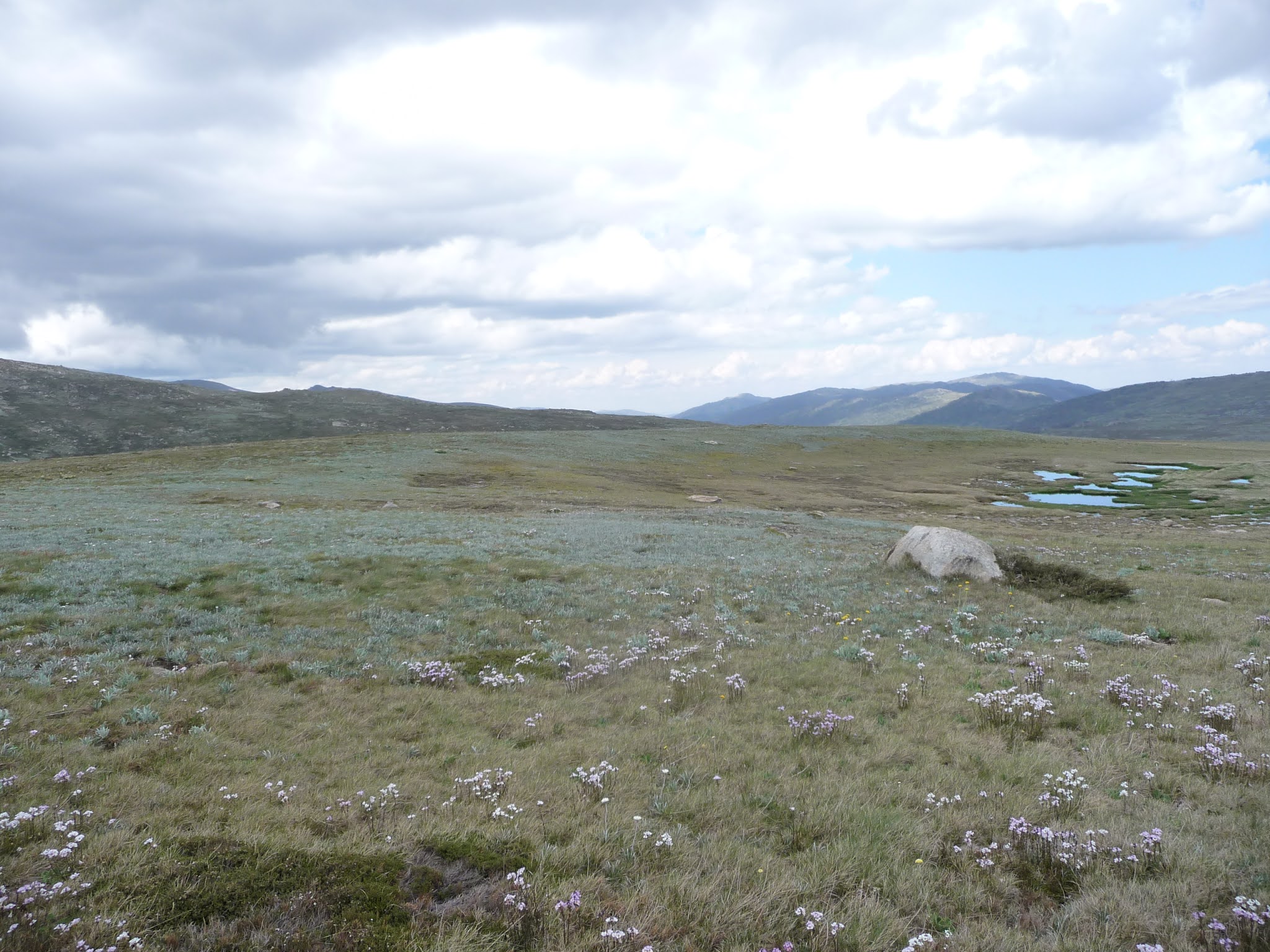
Working your way up the hill through Pounds Creek Flats, depending on the time of year, but most likely there will be snow and plenty of small creeks to work your way through.
This is the original Day 1 Camping Area for the hike but we found at having done only 7km and around 2 hours of walking we pressed ahead.
Head upwards through the creek valley, past the Mt Twynam snow areas which appears on your right.
 |
| Pounds Creek Flats with Mt Tynam in the distance. |
Further up you need to head to the left which will guide towards large boulders.
 |
| Heading up over ridge to Blue Lake |
Working over the boulders the view opens up to Blue Lake which should be on your right.
 |
| Blue Lake |
Be very careful here as there are high dropoffs.
From up high here you should have a good view of Blue Lake.
You need to head down to its bank where the outflow point feeds Hedley Tarn. There should be the start of the Blue Lake Track.
From up high here you should have a good view of Blue Lake.
You need to head down to its bank where the outflow point feeds Hedley Tarn. There should be the start of the Blue Lake Track.
 |
| The Blue Lake track starts down at the bank where Blue Lake feeds out. |
Work your way up Blue Lake Track and after 1km you reach the intersection with Main Ridge Track.
 |
| On Blue Lake track. Head right up Main Ridge track. |
Head right towards Carruthers Peak / Mt Townsend.
 |
| Main Ridge track towards Carruthers Peak. |
This is one of the riskiest parts of the walk with snow possibly covering the track.
Bypass the side track on the right near Carruthers Peak, this will be used to return back to Guthega on the last day.
 |
| Looking back along Main Ridge track. |
After about a hour you should notice Albina Lake down the righthand side of the track.
 |
| Albina Lake view from Main Ridge track. |
Look at setting up camp a reasonable distance from the lake & nearby Lady Northcote Creek.
From here you can look at doing the side-trip to Mt Townsend in the morning.
DAY2:
You can either leave your packs at camp, visit the peak and retrace your steps back out to Main Ridge track or take your packs some way up the hill and drop in the open to visit the peak. You could then take the southern side around Albina Lake to head back onto Main Ridge Track further east.
 |
| Heading up to Mt Townsend. |
Nearing the last 100m to Mt Townsend make your way through the boulders until you reach the cairn.
 |
| Nearly at Mt Townsend peak |
Once you have come down your Mt Townsend sidetrip head back to the Main Ridge track.
 |
| View of Main Ridge track across Albina Lake, from Mt. Townsend. |
Theres easy walking along the southern side of Albina Lake, following the contours you'll see Main Ridge track heading east upwards towards Mt Kozi.
 |
| Main Ridge track heading towards Mt Kozi. |
This will be probably you busiest part of the trip. Drop your packs at the Mt Kozi side track entrance.
 |
| Mt Kozi path. |
It only takes a few mins to get to the peak.
 |
| Mt Kozi peak. |
You have now been at the 2 highest peaks in Australia.
From here you can see Rawson Pass towards the east which is the next destination.
 |
| View of Rawson Pass from Mt. Kozi. |
Continue east along Main Ridge track to Rawson Pass. The public toilets here are the last ones you'll see until you finish the trek.
 |
| Rawson Pass junction |
Either here or a 20min walk along Summit Trail to Seaman's Hut are the best places for lunch as this walk goes off track after the hut.
 |
| Rawson Pass junction. |
After 20 mins along the gravel track you'll reach Seaman's Hut.
 |
| Approaching Seaman's Hut |
From here we head off track behind the hut and down the valley towards Foreman's Hut.
 |
| Heading down into Foreman's Hut valley |
Heading down the valley you'll be walking through foot high scrub towards the northern bank of the Snowy River. There will be at least one creek crossing but they are easily crossed using boulders in the area.
 |
| Skirting along the Snowy River |
Once over the creek, skirt near along the northern bank of the Snowy River.
You're probably looking at about 2 hours of this before the remnants of Foremans Hut comes into view further down the valley as it levels out.
 |
| Foreman's hut in the distance. |
This will be your 2nd nights camping area with the Snowy River as your water supply nearby.
Note: You are only about 1km from Charlottes Pass across Snowy River incase of emergency.
Note: You are only about 1km from Charlottes Pass across Snowy River incase of emergency.
 |
| Foreman's Hut camp arera |
The final day starts with short walk back onto Main Range Track near Foremans Crossing.
Head away from the Snowy River uphill until you reach the Main Ridge track.
 |
| Main Ridge track heading back up towards Blue Lake intersection. |
Head left uphill NW away from Snowy River for an hour before we reach the Blue Track/Main Ridge paved intersection we visited on the first day.
 |
| Heading towards Blue Lake intersection. |
At the intersection TURN LEFT and head up towards Carruthers Peak again.
After about 1km at the Main/Ridge Mt Twynam intersection, turn right and head around NW of Blue Lake towards Mt Twynam.
After about 1km at the Main/Ridge Mt Twynam intersection, turn right and head around NW of Blue Lake towards Mt Twynam.
 |
| Track to Mt Twynam |
You could have lunch on the Mt Twynam peak or somewhere further down along the creek valley.
There is very little shelter from the sun in this area.
Head off from Mt. Twynam in an easterly direction towards the Pounds Creeks Flat area.
Head off from Mt. Twynam in an easterly direction towards the Pounds Creeks Flat area.
 |
| View of Blue Lake from Mt Twynam area |
Backtrack you way back down the mountain using the Snowy River & Illawong Hut as your guide to the suspension bridge.
 |
| Marker tree for suspension bridge crossing. |
Work you way back past Illawong Hut, Blue Cow Creek and back up to the carpark.
 |
| Snowy River |
Jindabyne is your best place to get resupplied and freshened up after your trip.