Walk: Badger Creek Weir.
Distance/Type: 4km / Return
Terrain/Rating: Flat / Easy / No wheelchair access to weir.
Start Time: 11am
Start Location: Badger Creek Picnic area.
Trip Detail Summary:
Please note that in 2016 this area was completely devastated by a storm. All amenities were destroyed and as of 2018 trees were still down and virtually nothing has been done to clean it up.
Walk from Badger Creek Picnic area, crossing bridge and head up Lyrebird track along the creek before crossing back over the creek, heading up Coranderrk Track to the weir. Head back to Picnic area completely along the main Coranderrk Track.
Trip Details:
Came across this little gem of a picnic ground and short walk park by accident.
Originally heading towards Marysville via the Maroondah Hwy I had to divert to Warburton due to the highway being closed just north of the Maroondah Reservoir.
Badger Creek is a little town about a 5 minute drive south east from Healseville along Don Rd.
The main attraction is the Weir which is reached by turning left up the Badger Creek Weir Rd.
 |
| Badger Creek Weir entrance |
 |
| Badger Creek Picnic area. |
Having no real idea of the walks in the area I headed to the weir via what looked like the longer more scenic track to the left along the creek called Lyrebird Track.
 |
| Track across creek to Lyrebird Track. |
Just after crossing the creek theres an intersection where Lyrebird Track heads off to the right.
 |
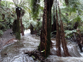
| Lyrebird Track slightly flooded. |
 |
| Coranderrk Track. |
 |
| Badger Creek Weir bridge. |
All in all a nice easy 40 min hike that you could take the family on.
 |
| Badger Creek Weir |


No comments:
Post a Comment